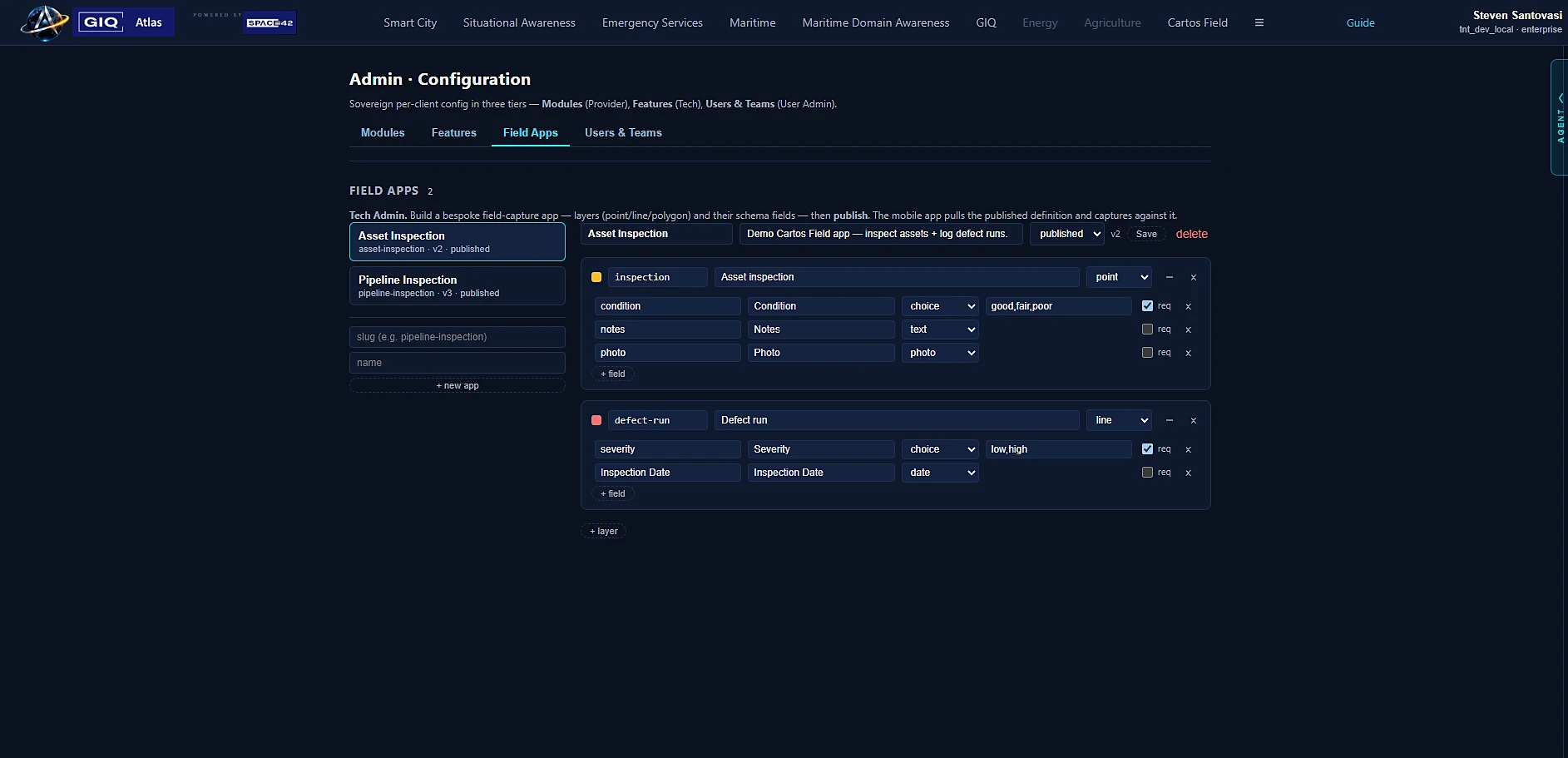
Layers and schema, defined in the console
Compose a field app from layers and typed schema fields with validation — the same data fabric the analysts use. What you define here is what the field worker sees in the native app.
Cartos · Phase III — Shipping (v1.0)
Not one app — a platform for standing up bespoke field apps from common pieces. Admins define layers, schemas, and forms in a web console; field workers run them in a native app that works offline and syncs into the Cartos data fabric. The sovereign ground-truth edge of the platform — and v1.0 is now built and in tester distribution.
The thesis
Phases I–II serve the analyst — someone at a desk reasoning over imagery. But the picture is only as good as the ground truth feeding it. Today that ground truth is collected in disconnected tools that don't feed a sovereign AI platform, don't close the loop back to change detection or 3D, and aren't sovereign.
Phase I–II sells analyst seats — tens to low-hundreds per organisation. Phase III sells field seats — hundreds to thousands — plus entry into two large, fast-growing adjacent markets: field data collection and reality capture.
Shipped · v1.0
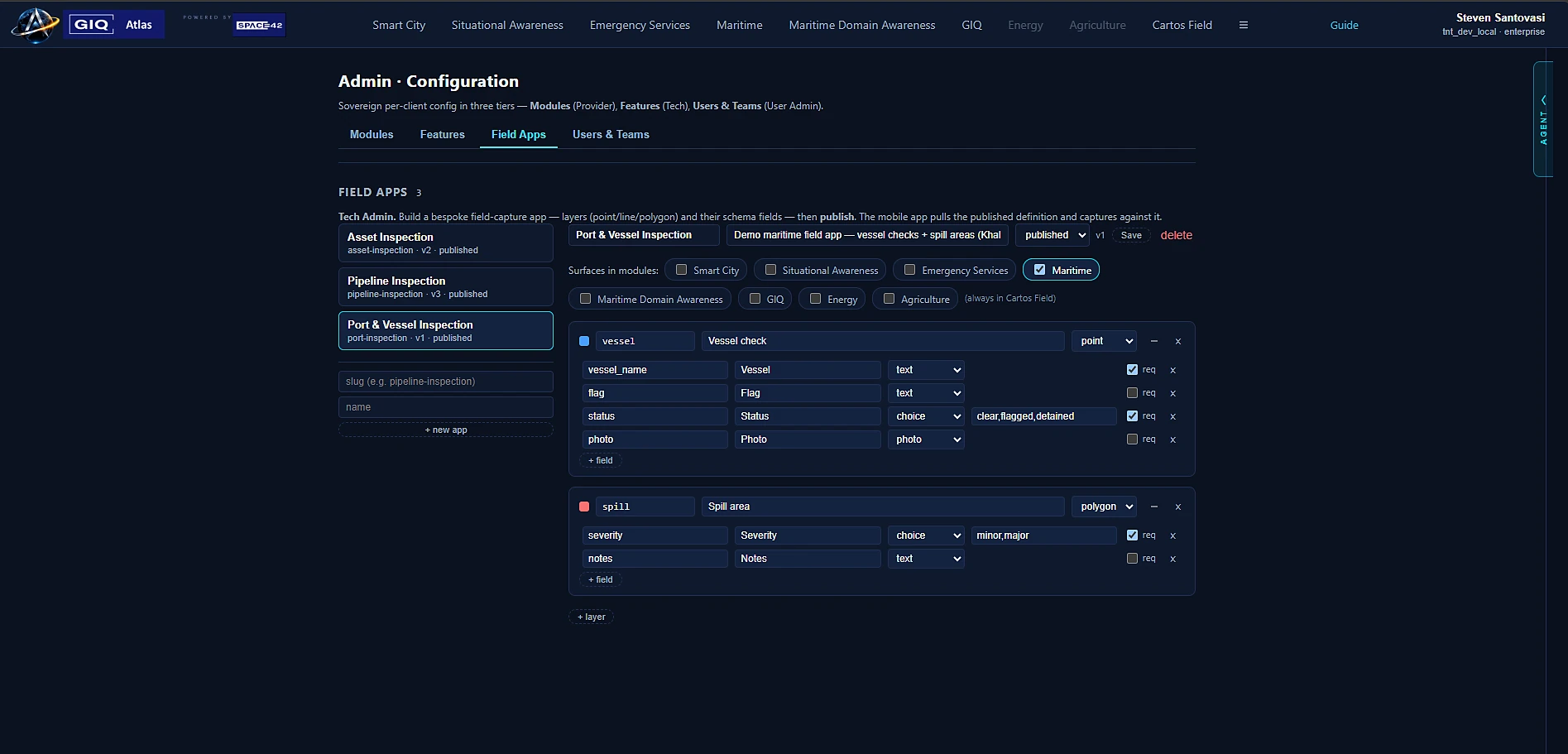
A Tech Admin stands up a bespoke field app in the web console: pick the layers, define the schema fields, and choose which modules the captured data surfaces in. No dev cycle, no app-store round-trip per app — the runtime is one native app that loads whatever the console defines.
Compose a field app from layers and typed schema fields with validation — the same data fabric the analysts use. What you define here is what the field worker sees in the native app.
Assign a field app to Smart City, Maritime, or Emergency Services and its captures land on that module's map — queryable by the AI agent there, not stranded in a separate field tool. This is the field-to-AI loop, made literal.
Product decision
Already in field hands: Android tester distribution is live via Firebase App Distribution, and iOS TestFlight is wired (pending Apple enrollment).
The web can't reach LiDAR/ARKit, ARCore depth, or robust iOS background sync — so the field app is cross-platform native, while the admin/app-builder console is web.
| Option | Verdict | Why |
|---|---|---|
| HTML5 / PWA as field app | Companion only | No access to Apple LiDAR/ARKit or ARCore depth from web; weaker offline + background sync on iOS. Ideal for a light viewer and the admin console. |
| Fully native (Swift + Kotlin) | Overkill for v1 | Best device access, but two codebases double the cost — not justified until scale demands it. |
| Cross-platform native (Flutter / RN) | Recommended | One codebase across iOS + Android, near-native offline & performance, mature map/storage plugins; native modules added for LiDAR, GNSS/RTK. |
Architecture fit
Captured features land in the data fabric as lineage-tracked observed datasets — joining the same derived-data graph, change detection, and 3D pipeline the analysts already use.
Release scope
Offline capture with deferred sync is the normal case for field work, so it was v1 — the app fails its core job otherwise. v1.0 is now built and in tester distribution. Advanced offline and reality capture follow.
Market sizing
Market anchors from public 2025–26 industry reports. Treat the TAM/SAM/SOM model as illustrative and assumption-driven, not a forecast.
Competitive landscape
Every serious tool does offline capture, forms, geometry, and photos. None is sovereign, inside an integrated GeoAI + owned-imagery platform, closing the loop from field to AI. That intersection is the entire opening.
| Capability | Esri suite | Fulcrum | QField / Mergin | Trimble | Cartos Field |
|---|---|---|---|---|---|
| Offline capture & sync | ✓ | ✓ | ✓ | ✓ | ✓ |
| Configurable bespoke apps | ✓ | ✓✓ | partial | ✓ | ✓ |
| High-accuracy GNSS / RTK | ✓ | ✓ | ✓ | ✓✓ | v2 |
| Sovereign / in-territory | ✗ | ✗ | self-host | ✗ | ✓ core |
| Integrated GeoAI + owned imagery | ✗ | ✗ | ✗ | ✗ | ✓ |
| Field → AI loop (change / 3D / graph) | ✗ | ✗ | ✗ | ✗ | ✓ |
| In-field 3D / 4D reality capture | partial | ✗ | ✗ | partial | v2/v3 |
| Auditable lineage to analytics | partial | partial | ✗ | ✗ | ✓ |
| Market presence / maturity | ✓✓ | ✓ | ✓ | ✓ | early |
“Everyone else sells a field tool. Cartos Field is the sovereign ground-truth edge of an AI geospatial platform — for buyers who can't put their field data in someone else's cloud and want it to come back as intelligence.”
Go-to-market
| # | Priority segment | Why it fits |
|---|---|---|
| 1 | Utilities & critical infrastructure | Inspection, asset capture, outage/change verification — high seat counts, sovereignty-sensitive. |
| 2 | Government & defence | Field ISR, asset/border survey, digital-twin programs — sovereignty is a hard requirement. |
| 3 | Construction & site | Progress capture, as-built, 3D from the field. |
| 4 | Environment & compliance | Monitoring, sampling, geotagged evidence. |
| 5 | Telecom | FTTx and tower/site survey. |
| Success metric | Target signal |
|---|---|
| Field seats per account | Order-of-magnitude above analyst seats |
| Offline reliability | Zero data-loss incidents in pilots |
| Time-to-stand-up a bespoke app | Hours in the console, not a dev cycle |
| Field data → derived graph | % of captures reused by analysts / models |
| Survey-grade attach rate | Accounts adding external GNSS / RTK |
Design partner program
Utilities, gov/defence, construction, environment, telecom — if your field data can't live in someone else's cloud, let's talk. Engagements run under NDA.