
Infrastructure
Async, cost-honest compute
Heavy AI and 3D work runs as asynchronous jobs on a GPU tier that reports its own cost — the platform never blocks, and spend is observable from day one.
Cartos · Phase II — In development
Phase I made Cartos see and stream the world. Phase II makes it reason about change, build in 3D, derive new analysis-ready data, and write its own auditable conclusions — turning a visualization substrate into one that produces intelligence.
The shift
Today an analyst studies imagery, then leaves the platform to do the thinking — change detection in one tool, 3D in another, the brief in a word processor. Cartos pulls that whole workflow inside, and hands most of it to the agent.
Own & open imagery, telemetry, and 3D in one sovereign globe. today
An AI analyst runs the analysis and produces governed, reusable data over your geography.
One click turns a session into a branded, signed deliverable — methodology written for you.
The capabilities
| ID | Capability | What you can show | Role |
|---|---|---|---|
| M03 | GeoAI Agents & Derived Data | Agents mint reusable, governed datasets over an AOI that compound across sessions | The moat |
| M02 | Comprehensive Reporting | A session → a signed HTML / DOCX / PDF report with an auditable methodology section | The deliverable |
| M01 | Temporal Change Detection | Two epochs over an AOI → a georeferenced change layer with confidence | The analytic |
| M04 | Gaussian Splat 3D map viewer live | Photoreal, georeferenced 3D served GPU-free inside the map — incl. SuperSplat SOGS import | Reality capture |
| M05 | AOI → 3D Buildings | Reconstruct textured LOD 2.5/3 buildings from imagery, with an honest accuracy label | Digital twin |
Reality capture · live now
A 3D Gaussian splat reconstructs the real world from ordinary photos or drone imagery as millions of soft, coloured points — photoreal, not a simplified model. Cartos serves them GPU-free in the browser, anchored in their real location: fly through a site, a corridor, or a landmark, then pitch to ground level and walk it.
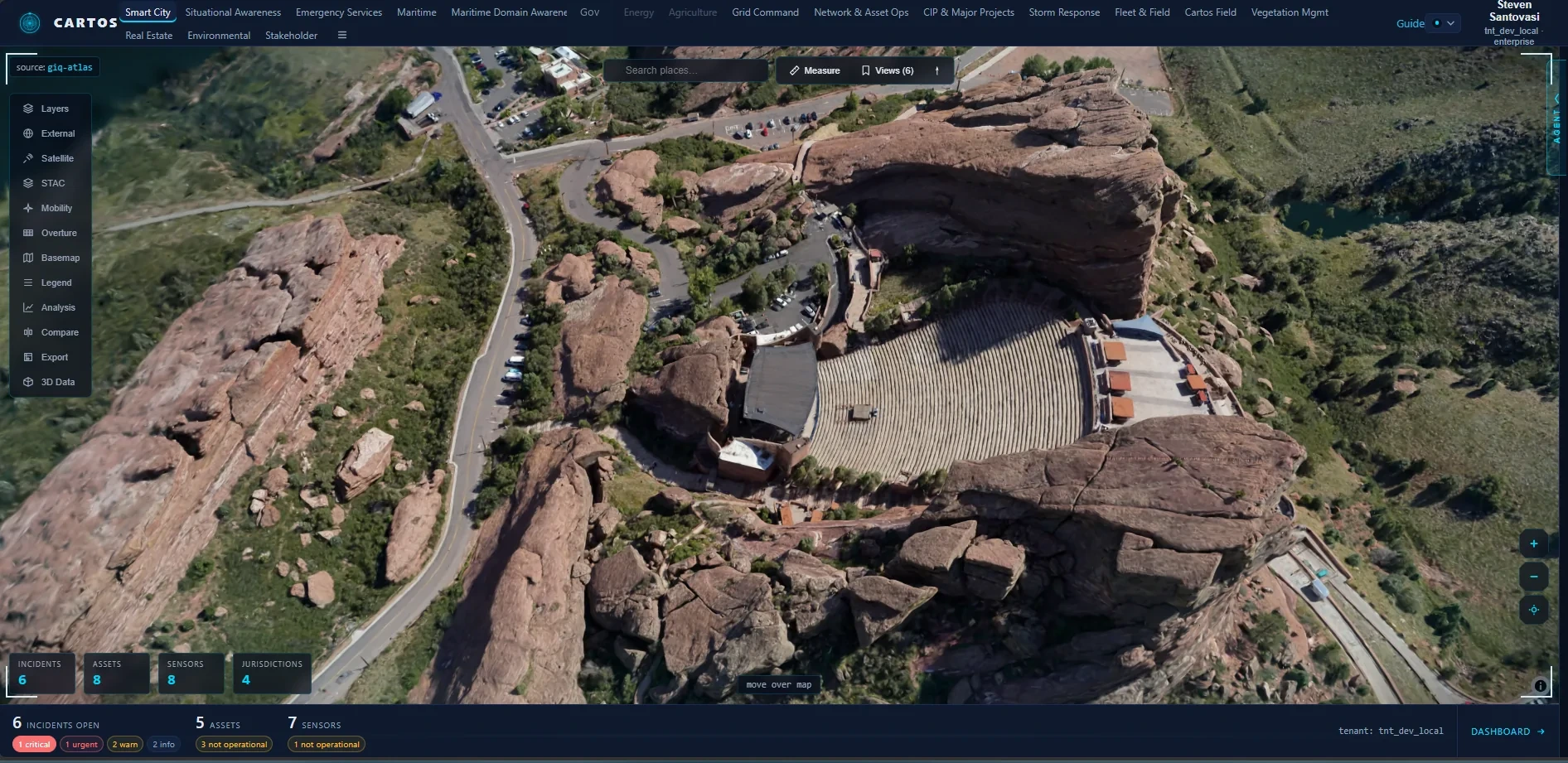
A phone or drone flyover becomes a navigable 3D asset — no LiDAR rig, no manual modelling.
Imports the compressed, streamable SOGS bundle (SuperSplat / PlayCanvas) — level-of-detail tiling, ~15–20× smaller than raw — plus .splat / .ksplat / .ply / .spz.
Client-side WebGL serving: no server GPU and nothing leaves your perimeter to view it. Generation is the only GPU step, and stays gated.
How it works
The photoreal 3D wins the room — but the loop wins the contract. Reusable intelligence and auditable reporting are the connective tissue that make every other capability worth paying for.
“Cartos is the sovereign geospatial intelligence platform that reasons, builds in 3D, and documents itself.”
Delivery
Build the loop (derived data + reporting) first, then the analytic, then the 3D spectacle. Every capability ships independently behind a flag. Figures are planning estimates in engineer-weeks, not quotes.
| Wave | Modules | Goal | Effort |
|---|---|---|---|
| 2A | M03 derived data + M02 reporting | Run an analysis → walk away with a finished, auditable report | ~26 eng-wks |
| 2B | M01 change detection | First high-value analytic, riding the derived-data graph | ~12 eng-wks |
| 2C | M04 splats → M05 3D buildings | The visual differentiator, packaged by the report engine | ~24 eng-wks |
| Total | Five capabilities, independently shippable | One AOI, end to end — reconstruct, detect change, generate the report | ~58 eng-wks |
Heavy AI and 3D work runs as asynchronous jobs on a GPU tier that reports its own cost — the platform never blocks, and spend is observable from day one.
Model weights and compute stay inside your boundary; non-sensitive work can optionally burst, but sovereign is the default route.
Every report's methodology is generated from the work that was actually executed — confidence on every change layer, an honest grade on every reconstruction.
Design partner program
The earliest wave delivers the signed-report moment — the fastest way to prove the value on real geography. Engagements run under NDA.